

TL;DR:
- The Moroccan Atlas Mountains stretch 2,500 km across Morocco, Algeria, and Tunisia, featuring distinct subranges with unique terrains and cultures.
- The High Atlas offers alpine peaks, the Middle Atlas lush forests and wildlife, and the Anti-Atlas ancient rocks and argan groves, providing diverse experiences for travelers. Trekking Mount Toubkal involves a 2-3 day route from Imlil, where acclimatization at the Neltner Refuge greatly reduces altitude sickness risks.
The Moroccan Atlas Mountains form North Africa’s most dramatic mountain spine, stretching 2,500 km across Morocco, Algeria, and Tunisia, with Mount Toubkal rising to 4,167 m as the continent’s highest peak north of the Sahara. Three distinct subranges divide the range: the High Atlas, Middle Atlas, and Anti-Atlas, each with its own terrain, climate, and cultural character. For hikers and travelers, this means one country delivers alpine summits, cedar forests, ancient Amazigh villages, and desert-edge landscapes within a single itinerary. Whether you plan a two-day Toubkal summit push or a slow village-to-village cultural walk, the Atlas region rewards preparation and curiosity in equal measure.
What are the main differences among the Atlas Mountains’ subranges?
The three subranges of the Moroccan Atlas Mountains are not interchangeable. Each one offers a fundamentally different physical and cultural experience, and choosing the right one shapes your entire trip.
High Atlas: peaks, passes, and snow
The High Atlas is the tallest and most visited subrange. It contains Mount Toubkal, the Tizi n’Tichka pass at 2,260 m, and dozens of peaks above 3,000 m. Snow covers the upper elevations from roughly November through May, which transforms the range into a winter mountaineering destination and limits access to certain trails. The Tizi n’Tichka Pass connects Marrakech to Ouarzazate and is one of the most scenic drives in Morocco, cutting through red-rock gorges and Amazigh villages perched on ridgelines. Summer brings clear skies and dry trails, making it the peak season for non-technical trekking.
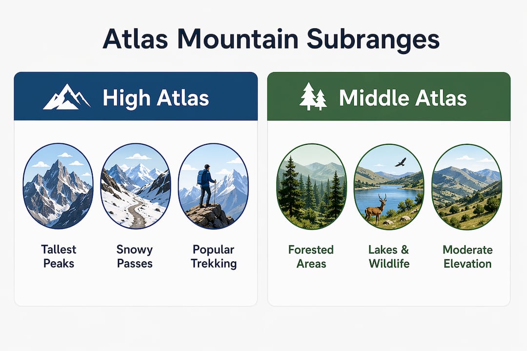
Middle Atlas: forests, lakes, and wildlife
The Middle Atlas sits at a more moderate elevation and feels entirely different from its southern neighbor. Cedar forests dominate the landscape around Azrou and Ifrane, and the region is one of the few places in the world where you can watch wild Barbary macaques move through old-growth trees. The town of Ifrane is sometimes called “Morocco’s Switzerland” for its alpine architecture and cool temperatures. Hikers here find gentler gradients and lush scenery rather than high-altitude challenges.
Anti-Atlas: ancient rock and argan groves
The Anti-Atlas is geologically the oldest part of the range, with exposed Precambrian rock that gives the landscape a raw, stripped-down quality. Elevations are lower, rainfall is scarce, and argan trees replace the cedar forests of the north. The region around Tafraoute offers dramatic pink granite formations and some of the least-crowded trekking in Morocco. Travelers who want solitude and a sense of deep geological time will find the Anti-Atlas unlike anywhere else in the country.
| Subrange | Elevation range | Key feature | Best for |
|---|---|---|---|
| High Atlas | Up to 4,167 m | Toubkal summit, Tizi n’Tichka | Summit trekking, alpine scenery |
| Middle Atlas | 1,000 to 2,000 m | Cedar forests, Barbary macaques | Wildlife, gentle hiking |
| Anti-Atlas | 500 to 2,500 m | Precambrian rock, argan trees | Solitude, geological interest |
Key terrain highlights across all three subranges:
- High Atlas valleys like Imlil and Ourika offer direct access to serious mountain routes
- Middle Atlas lakes such as Dayet Aoua attract migratory birds and casual walkers
- Anti-Atlas granite formations near Tafraoute reward photographers and off-the-beaten-path seekers
- Snow season in the High Atlas runs November to May, directly affecting trail conditions and pass accessibility
What should hikers know about trekking Mount Toubkal?
Mount Toubkal is the defining trek of the Moroccan Atlas Mountains, and the classic route covers 15 to 18 km round trip over two to three days, starting from Imlil village. The ascent gains roughly 2,300 m in elevation from Imlil to the summit, which makes fitness and pacing the two most critical variables for success.
The standard two-day itinerary
Day one begins in Imlil at around 1,740 m and follows a well-worn mule track through the village of Aremd before climbing steeply to the Neltner Refuge at 3,207 m. Most trekkers reach the refuge in four to five hours. Day two starts before dawn for the summit push, which takes another three to four hours of steep scree and rocky terrain. The descent back to Imlil typically takes five to six hours total, making the full round trip achievable in two days for fit hikers.
Why the Neltner Refuge matters
The overnight stop at the Neltner Refuge is not simply a logistical convenience. Skipping the refuge and attempting a single-day summit dramatically increases the risk of altitude sickness, headaches, and nausea on summit day. Sleeping at 3,207 m allows your body to begin adjusting to reduced oxygen levels before the final push above 4,000 m. The refuge provides dormitory beds, basic meals, and gear storage, so you do not need to carry a full pack to the top.
Guide requirements and costs
Morocco does not legally require a guide for Toubkal, but hiring one is strongly recommended for safety and navigation. Licensed local guides cost approximately 400 to 600 MAD per day, which translates to roughly 40 to 60 EUR. Full group or private logistics packages, including mule hire, refuge booking, and transport from Marrakech, run between 300 and 700 EUR depending on group size and comfort level. That cost buys you more than navigation. Local guides carry weather knowledge, speak Tachelhit with village residents, and can make real-time decisions about route changes when conditions shift.
Pro Tip: Book your Neltner Refuge bed at least two weeks in advance during July and August. The refuge fills quickly in peak season, and arriving without a reservation means sleeping on the floor or turning back.
Seasonal windows for the Toubkal trek
The best months for a non-technical summer ascent are June through September, when trails are dry and snow-free above 3,500 m. October and May are viable shoulder-season options but require checking conditions at the refuge. Winter ascents from December through March demand crampons, ice axes, and mountaineering experience. Even summer treks require good fitness and respect for altitude, as the steep scree above the refuge catches many underprepared hikers off guard.
- Arrive in Imlil the evening before your trek to rest and acclimatize at 1,740 m
- Hike to the Neltner Refuge on day one, taking four to five hours at a steady pace
- Start the summit push by 5:00 AM on day two to avoid afternoon cloud buildup
- Descend fully to Imlil on day two or split the descent across a third day
- Arrange transport back to Marrakech in advance, as shared taxis fill up fast
How do weather and terrain affect hiking in the Atlas Mountains?
Weather in the Moroccan Atlas Mountains varies more sharply than most travelers expect, and the difference between valley and summit conditions can be extreme. In May, Marrakech regularly reaches around 90°F (32°C), while nights above 3,000 m drop to near freezing with possible snow patches still on the ground. That 60-degree swing within a single day’s drive is not unusual and catches underprepared hikers in serious trouble.
The High Atlas snow window runs from November through May, and its effects reach beyond just the summit. Mountain passes like Tizi n’Tichka at 2,260 m can close temporarily after heavy snowfall, disrupting road travel between Marrakech and the south. Valley trails below 2,000 m remain accessible year-round, but the upper routes demand seasonal awareness.
Essential gear considerations for Atlas trekking:
- Waterproof hiking boots with ankle support for scree and wet rock
- Layering system including a down jacket for nights above 2,500 m
- Trekking poles to reduce knee strain on steep descents
- Sun protection at altitude, where UV exposure increases significantly
- Headlamp for pre-dawn summit starts and refuge navigation
Pro Tip: Pack a lightweight fleece and a waterproof shell even on summer treks. Afternoon thunderstorms can develop quickly above 3,000 m between July and August, and the temperature drops fast once the sun disappears behind a ridge.
Winter trekking in the High Atlas is a different discipline entirely. Routes above 3,000 m require crampons, ice axes, and the ability to self-arrest on steep snow slopes. Guided mountaineering packages from Moroccotravel1 and other operators cover this equipment and training gap for travelers who want a winter summit without prior alpine experience.
What cultural experiences can you find in the Atlas Mountains?
The Moroccan Atlas Mountains are home to the Amazigh people, also known as Berbers, whose villages, language, and traditions predate Arab settlement in Morocco by thousands of years. Berber culture and village life are inseparable from Atlas trekking, and the most rewarding itineraries treat cultural interaction as a destination in itself, not a backdrop.
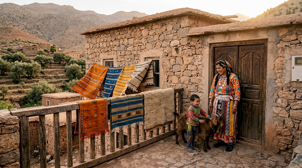
Villages like Imlil, Aremd, and Tachedirt sit along the main trekking corridors and offer guesthouses run by local families. A night in one of these guesthouses typically includes a shared dinner of tagine or couscous, mint tea served in the traditional three-pour style, and conversation with hosts who have guided trekkers for generations. This is not a staged experience. It is daily life that travelers are invited to observe and participate in.
Village-to-village trekking routes through the High Atlas valleys offer something that a straight Toubkal summit push does not: time. Moving between Imlil, Aremd, and the Azzaden Valley over three or four days gives you the rhythm of mountain life, the chance to watch women weaving in doorways, and the experience of sharing a meal with a family whose grandfather built the house. Many tourist trekking packages follow predictable routes, so travelers who want genuine cultural depth should specifically request village stops and off-route pathways when booking.
Key ways to deepen cultural engagement on Atlas treks:
- Stay in family-run guesthouses rather than larger lodges where possible
- Learn a few words of Tachelhit, the local Amazigh language, before you arrive
- Ask your guide to arrange a home-cooked meal rather than a restaurant stop
- Visit a weekly souk in villages like Asni or Moulay Brahim for local market culture
- Bring small practical gifts like school supplies rather than candy for village children
For travelers interested in luxury cultural immersion alongside trekking, boutique mountain lodges in the Ourika Valley combine high-end accommodation with direct access to Amazigh villages and guided cultural walks.
How to fit Atlas Mountains trekking into a Morocco itinerary
Marrakech is the logical gateway to the Moroccan Atlas Mountains for most international travelers. The city sits 60 to 65 km from Imlil, and the drive takes about 1.5 hours by shared taxi or private transfer. That proximity makes it possible to combine a two-day Toubkal trek with a full Marrakech city stay without losing time to long transfers.
A practical 10-day Morocco itinerary might look like this:
- Days 1 to 2: Marrakech medina, souks, and Djemaa el-Fna
- Days 3 to 5: Imlil and Toubkal trek with Neltner Refuge overnight
- Days 6 to 7: Ouarzazate and Draa Valley en route to the Sahara
- Days 8 to 9: Merzouga desert camp and camel trek
- Day 10: Return to Marrakech via Dades Gorge
For travelers with 14 days, the M’Goun Circuit in the Central High Atlas adds a four- to five-day loop through remote Berber valleys with far fewer crowds than the Toubkal corridor. The M’Goun massif reaches 4,071 m and offers a genuine wilderness experience with mule support and village guesthouses along the route.
| Itinerary length | Atlas component | Best combination |
|---|---|---|
| 7 days | 2-day Toubkal trek | Marrakech plus desert day trip |
| 10 days | 3-day Toubkal plus Ourika Valley | Marrakech, desert, and Fes |
| 14 days | M’Goun Circuit or extended High Atlas | Full Morocco circuit, including coast |
The Ourika Valley day trip from Marrakech takes about one hour each way, with the hike to the first waterfall running closer to 40 minutes on the trail. That timing is longer than most guides suggest, so build in buffer time if you plan to combine it with an afternoon in the city.
For travelers who want professional support, Moroccotravel1 offers structured Morocco hiking tour packages that combine Atlas trekking with desert and city highlights in preplanned 10- and 14-day formats.
Key takeaways
The Moroccan Atlas Mountains reward travelers who combine physical preparation with cultural curiosity, and the Toubkal summit is only one of many reasons to go.
| Point | Details |
|---|---|
| Three distinct subranges | High Atlas, Middle Atlas, and Anti-Atlas each offer different terrain, elevation, and cultural character. |
| Toubkal trek basics | The classic route covers 15 to 18 km round trip over two to three days, starting from Imlil village. |
| Neltner Refuge is non-negotiable | Sleeping at 3,207 m before the summit push significantly reduces altitude sickness risk. |
| Weather swings are extreme | May temperatures range from 90°F in Marrakech to near freezing above 3,000 m on the same day. |
| Culture is the hidden reward | Village-to-village routes and Amazigh guesthouse stays deliver experiences that a summit push alone cannot. |
What the Atlas Mountains taught me about slow travel
Most travelers arrive in the Atlas Mountains with Toubkal as the goal and leave having discovered that the summit was the least interesting part of the trip. I have seen this pattern repeat across dozens of guided itineraries, and it still surprises me every time.
The altitude is real. The scree above the Neltner Refuge is steeper and more relentless than any photograph suggests, and the final 400 m to the summit cairn tests even fit hikers. But the moment that stays with most people is not the view from 4,167 m. It is the mint tea poured by a guesthouse owner in Aremd the night before, or the sound of a Tachelhit conversation drifting through a stone-walled courtyard at dusk.
Local guides are undervalued in a way that frustrates me. Travelers often treat them as optional extras or bargaining chips in the booking process. A licensed Atlas guide is a safety system, a cultural interpreter, and a weather forecaster rolled into one. Mountain weather and route visibility can change within an hour at altitude, and the decision to turn back or push forward is one that requires local knowledge, not bravado.
My practical advice: build at least one extra day into any Atlas itinerary and tell your guide you want to go somewhere tourists do not usually go. The answer will almost always be worth it. The Atlas Mountains are large enough and diverse enough that even experienced Morocco travelers consistently find routes and villages they have never encountered before. That depth is what makes this range worth returning to.
— Moroccotravel1
Plan your Atlas Mountains adventure with Moroccotravel1
Moroccotravel1 designs guided Morocco tours that treat the Atlas Mountains as a centerpiece, not a side trip. The 14-Day Morocco Grand Tour combines Toubkal trekking, Amazigh village stays, Sahara desert camps, and Marrakech city exploration into a single itinerary with private transport, licensed mountain guides, and hand-picked accommodation at every stage. For families, the 10-Day Morocco Family Tour includes Atlas day trips and cultural experiences scaled to mixed-age groups. Every package includes 24/7 support and full logistics coordination, so you focus on the mountains, and Morocco Travel 1 handles the rest. Reach out to start building your itinerary.
FAQ
What is the highest peak in the Moroccan Atlas Mountains?
Mount Toubkal, at 4,167 m, is the highest peak in the Moroccan Atlas Mountains and the tallest mountain in North Africa. It sits in the High Atlas subrange and is accessible from Imlil, a village near Marrakech.
How long does the Toubkal trek take?
The classic Toubkal trek takes two to three days, covering 15 to 18 km round trip with an overnight stay at the Neltner Refuge at 3,207 m. Most hikers summit on day two and return to Imlil the same day.
Do I need a guide to hike in the Atlas Mountains?
A guide is not legally required but is strongly recommended for safety, navigation, and cultural access. Licensed local guides cost approximately 400 to 600 MAD per day and provide critical support in changing mountain weather.
What is the best time of year for Atlas Mountains travel?
June through September offers the best conditions for non-technical trekking, with dry trails and snow-free routes above 3,500 m. May and October are viable shoulder months, while winter treks require mountaineering equipment and experience.
How far are the Atlas Mountains from Marrakech?
Imlil village, the main starting point for Toubkal treks, sits 60 to 65 km from Marrakech and is reachable in about 1.5 hours by road. Shared taxis and private transfers both operate this route daily.


